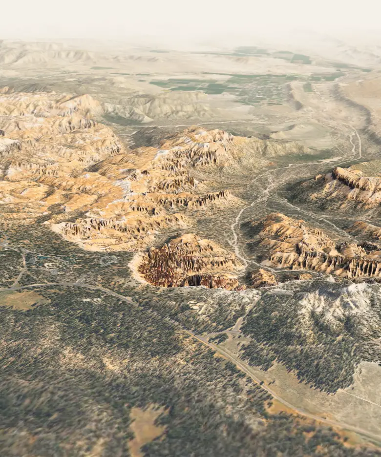
Bryce Canyon has the largest concentration of hoodoos on Earth.
A hoodoo is a pillar of rock left standing as the edge of a plateau wears away. Rain and ice remove softer layers faster than harder ones, so its sides jut out and pinch in, and a harder cap can shield the rock beneath it.
Ponderosa forest covers a nearly flat surface that ends abruptly at the rim. Rain and melting snow erode this edge one to four feet every century, so the amphitheater keeps working its way back into the plateau.
Every stage is visible from here. The rim erodes back into walls, called fins. Ice widens cracks until windows open through them. When a window’s top falls, the pillars left standing are hoodoos. The Queen’s Garden Trail starts here. Walk it in 3D
Thor’s Hammer stands almost directly below (see it in 3D). The rock is mostly limestone, laid down about 50 million years ago in a large freshwater lake that geologists call Lake Claron. Iron oxides make the vivid colors; manganese oxides add patches of pink and purple.
These cliffs belong to the Claron Formation. Its lower Pink Member is a “dirty” limestone with sand, silt and iron, which gives the red. The upper White Member is a purer freshwater limestone. To the north, the dense walls of Silent City fill the view.
The southern end of the amphitheater looks north along its full length, past the Wall of Windows near Inspiration Point to Silent City beside Sunset Point. In Southern Paiute oral tradition, as the park retells it, the hoodoos are Legend People turned to stone by Coyote.
The amphitheater’s drainages gather into Bryce Creek, usually a dry wash that runs only after summer rain or snowmelt. No river cut this bowl, which is why the park calls it an amphitheater, not a canyon.
Lidar elevation here · 2,188 m · 345 m below Inspiration Point
Drag to turn the model · Select a place for its story
USGS 3DEP lidar · USDA NAIP 2021 imagery · 30 km across · true vertical scale · About the model
01A hoodoo
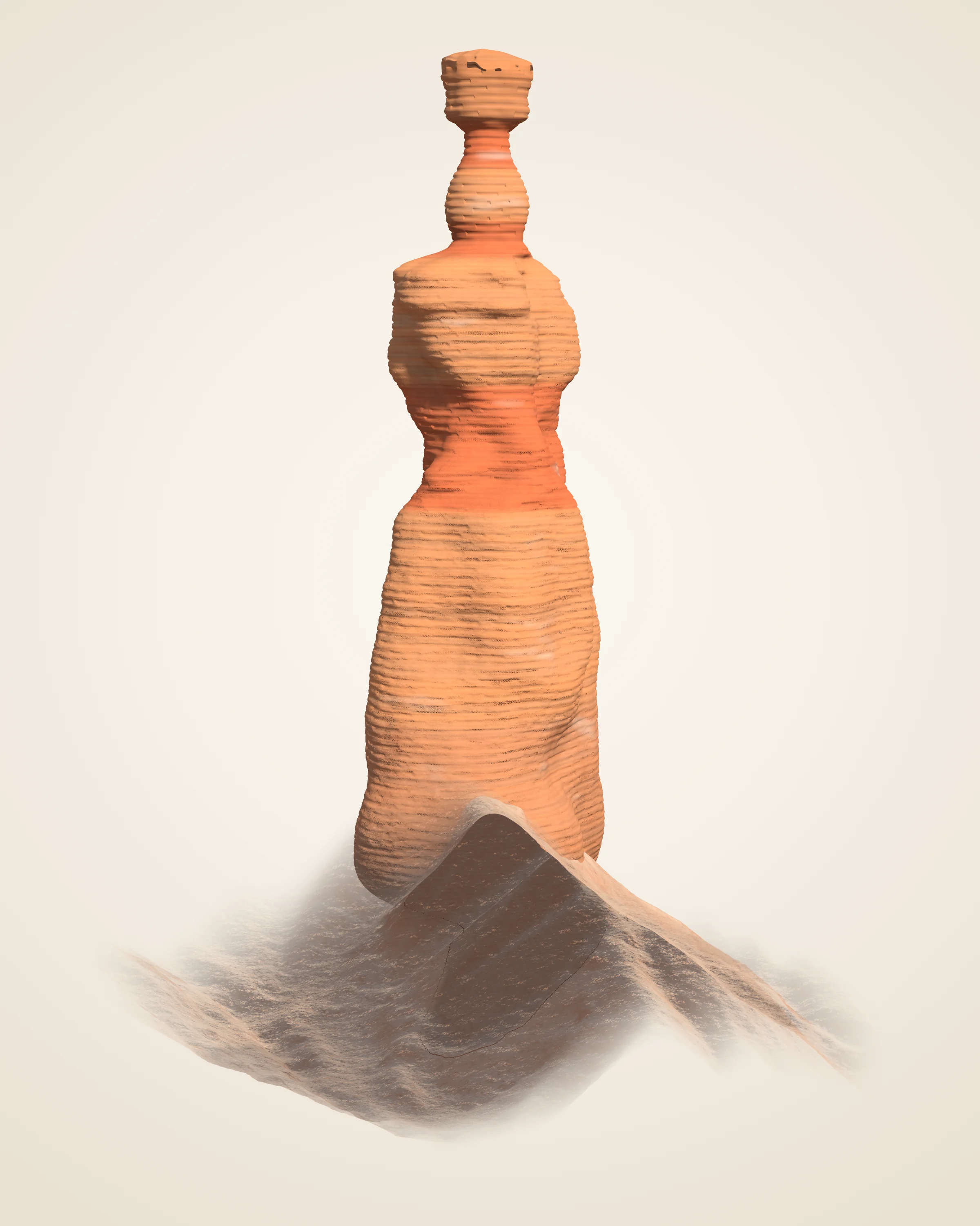
Thor’s Hammer
The park’s most famous hoodoo stands nearly below Sunset Point. This model is built from the laser returns of a 2018 U.S. Geological Survey flight, with the neck under the cap traced from a Park Service photograph. Turn it, cut it in half, or look at the returns themselves.
Top
2,401 m 7,878 ft
Height
About 28 m 90 ft above its uphill foot, 140 ft on the downhill side
Cap
About 3 m across on a neck about 1.3 m (4 ft) wide
Measured
About 3,500 laser returns on the pillar
Shape from USGS 3DEP lidar, 2018; the aircraft could not see under the cap, so the neck is traced from an NPS photograph taken from the west. Ground from the same lidar, trees left out. Colours and fine texture are drawn, not measured.Cut along the line from Sunset Point. Pale bands are harder beds, where the pillar juts out; red bands are softer beds, where it pinches in. The beds follow the measured outline; no rock was sampled.Each dot is one laser return from the 2018 USGS flight: rust on the pillar, grey on the ground, green on trees and small mounds. The aircraft saw the tops of ledges best and almost nothing under the cap.How the model was built · Full-size still, 2,400 × 3,000Cross-section along the line from Sunset Point, true scale. Outline and ground: USGS 3DEP lidar (2018) and the 1 m USGS elevation model; neck traced from an NPS photograph. Beds are read from where the outline juts out or pinches in; they are assumed flat-lying beyond the pillar, and no rock was sampled.
02An arch
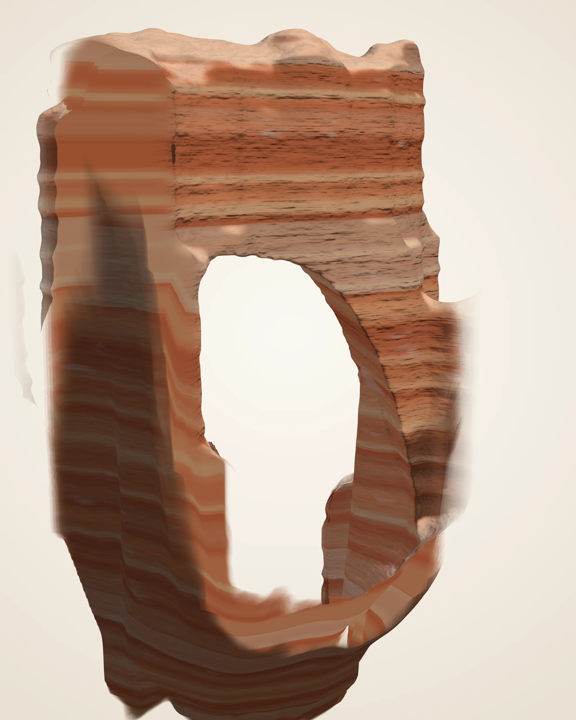
Natural Bridge
No stream ever ran through it. The Park Service calls it an arch, or window: frost, rain and gravity opened it in a wall of rock. This model is built from the same 2018 laser survey, with the opening traced from a U.S. Geological Survey photograph taken at the overlook. Turn it, look at the returns, or step from a solid fin to the day the span falls.
Top
2,632 m 8,635 ft, the top of the span
Opening
About 33 m tall 109 ft from the ground beneath to the underside of the span; about 19 m wide halfway up
Span
85 ft 26 m across, the Park Service’s figure; about 16 m of rock over the opening
Measured
About 14,000 laser returns on the span
Top of the rock from USGS 3DEP lidar, 2018. The aircraft could not see under the span, so the opening is traced from a USGS photograph taken at the overlook, where the laser’s slanted paths agree with it, and carried straight through the rock. Trees left out. Colours and fine texture are drawn, not measured.A fin. The window began in a solid wall. Water seeps into cracks and freezes at night; ice takes up almost 10 percent more room than water, and forces the cracks wider.A window opens. Rainwater dissolves the rock at the top and sides of the wall, and gravity pulls loose the weakened pockets at the center, opening the hole.Today. The arch looks solid and enduring, but weather is constantly chipping away at the opening.When the span falls. A window that grows too large to hold up its roof collapses, and a leg left standing becomes a hoodoo. The Park Service says this one may last hundreds or thousands of years, or could collapse tomorrow.Stages follow the Park Service’s account, drawn by shrinking or raising today’s opening. They are not dated shapes or a forecast.Each dot is one laser return from the 2018 USGS flight: rust on the fin, grey on the slopes, green on trees. Slanted pulses reached under the span from both sides; none could see its underside.How the model was built · Full-size still, 2,400 × 3,000Face on along the opening, true scale. Top of the rock and the ground: USGS 3DEP lidar (2018); the opening from the USGS photograph (2014) and the laser’s paths under the span, carried straight through the rock. Bands are drawn, not sampled. Bridge or arch: after the Park Service, “Bridges are carved by flowing water, whereas arches can be carved by everything else except flowing water.” Not to scale.
03A trail
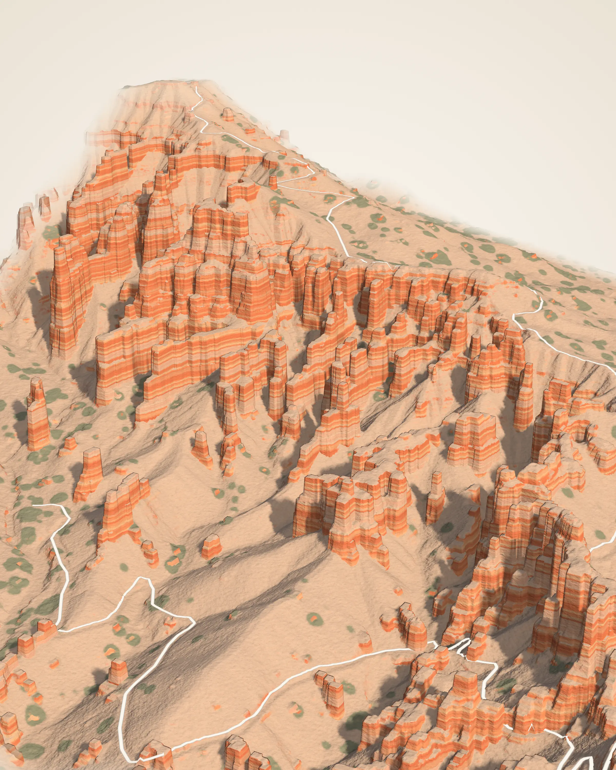
Queen’s Garden
The least difficult trail into the Bryce Amphitheater leaves Sunrise Point and winds down through a garden of hoodoos to one said to resemble Queen Victoria. This model is the same 2018 laser survey, about 430 m across, with the trail as mapped by OpenStreetMap volunteers. Walk it, turn the garden, or look at the returns.
Trail
1.8 mi round trip 2.9 km, the Park Service’s figure; 1.4 km each way on the mapped trail
Down
About 113 m 370 ft from the trailhead at Sunrise Point to Queen Victoria
The climb back
About 140 m 460 ft of climbing on the return, counting every rise; the Park Service lists 450 ft
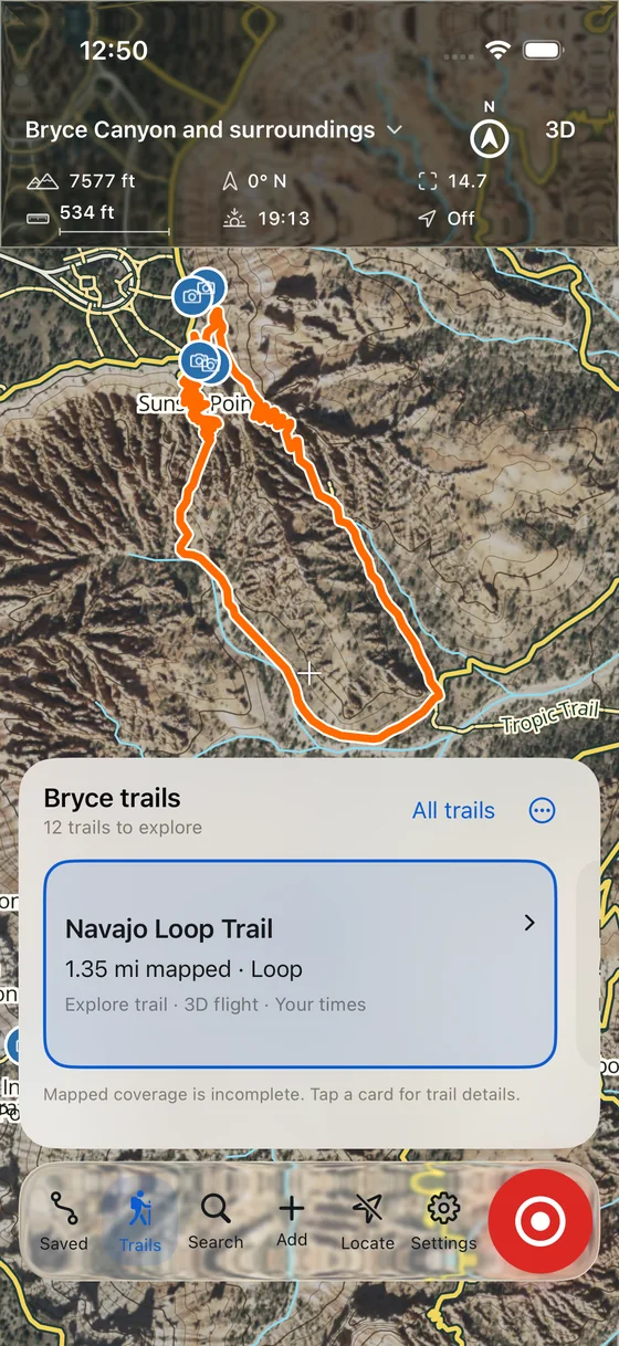
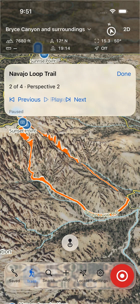
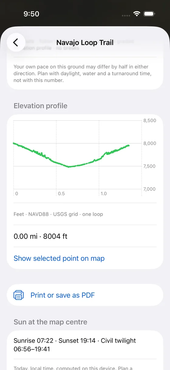
Hoodoo is our free app for the park. It draws Bryce’s trails on the same USGS lidar and aerial imagery as the model above, shows the climb back before you walk down, and explains the rock around you. Maps and articles are stored on your phone, so they still open when the signal drops below the rim.
Trails in 3DTwelve mapped trails on lidar terrain. Swipe the trail cards and the map flies to each one.
Fly it firstA short 3D flight around the Navajo Loop shows its switchbacks before you start down.
The climb backElevation profiles from the USGS grid, with sunrise, sunset and twilight for the day.
A field guideShort articles on hoodoos, rock layers, forests, wildlife and dark skies, each with its sources.
The Park Service’s exhibit at Sunrise Point breaks it into four stages. All four are in the model above; the tour stops at the best places to see them.
1
The rim wears back
Rain and snowmelt cut gullies into the edge of the plateau.
2
Fins
Harder caprock shields the softer rock beneath it, leaving narrow walls.
3
Windows
Water seeps into cracks and freezes. The ice expands, pries the rock apart and opens holes through the fins.
4
Hoodoos
As windows grow, their tops collapse. The columns left standing are hoodoos, and they keep changing.
Bryce Canyon Conservancy is a new, independent Utah nonprofit. We make free tools for understanding Bryce, and we are preparing to protect and look after land at its edges, with owners who want the same thing.
Founder Chase Kaczmarek brings a technical background to the work, including the Hoodoo app, and intends to do much of the fieldwork in person.
Now
Free geology field notes, the 3D model, and the Hoodoo app in development.
Incorporated in Utah on September 29, 2026. Tax exemption is not yet recognized. We hold no land, have no partners yet and are not accepting donations. Full status
Write to us
Landowners, neighbors, scientists and visitors: we would like to hear from you.